THE PACIFIC HIGH
The global circulation of winds on Earth creates semi-permanent high and low pressure systems. The Pacific High is a semi-permanent high pressure system that is located off the West Coast of North America, usually centered around 30oN and 150oW.
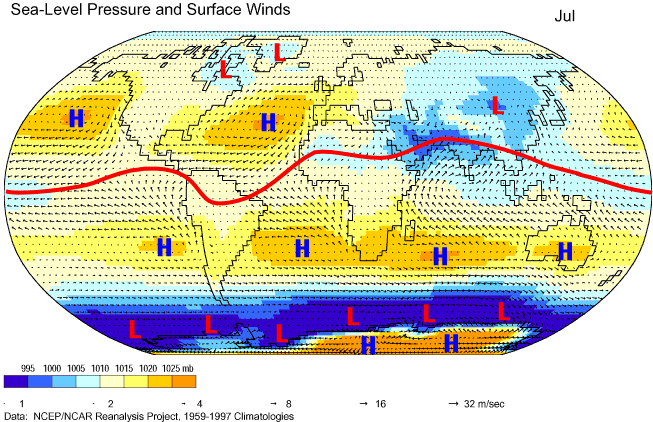
Figure 1: Mean July prevailing surface winds and centers of atmospheric pressure, 1959-1997. The red line on this image represents the intertropical convergence zone (ITCZ). Centers of high and low pressure have also been labeled. Note the Pacific High (blue H) off the west coast of the US. Image from http://www.physicalgeography.net/fundamentals/7p.html
In the Northern Hemisphere, winds blow clockwise around and away from surface high pressure systems such as the Pacific High. This causes divergence of air at the surface, leading to a sinking of air from above. Sinking air is typically associated with a stable atmosphere and either clear skies or horizontally extensive clouds.
In the Northern Hemisphere, winds blow clockwise around and away from surface high pressure systems such as the Pacific High. This causes divergence of air at the surface, leading to a sinking of air from above. Sinking air is typically associated with a stable atmosphere and either clear skies or horizontally extensive clouds.
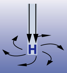
Figure 2: As winds blow clockwise and away from a high at the surface, cool air sinks from above toward the surface. Image from http://www.windows2universe.org/earth/Atmosphere/high_pressure.html
MARINE BOUNDARY LAYER
The sinking air associated with the Pacific High creates an interesting profile in the lower atmosphere known as the marine boundary layer (MBL). Sinking air warms by compression, and when it meets cool air over the ocean, an inversion can form. In an inversion, air temperature increases with height, which limits air mixing from below the inversion to above the inversion. This essentially puts a lid on how high clouds that form in the marine boundary layer will be able to grow to. Conditions below the inversion are often cool and cloudy, while conditions above the inversion can be warm and clear. The marine layer is often responsible for bringing dreary weather conditions to the coast of California.
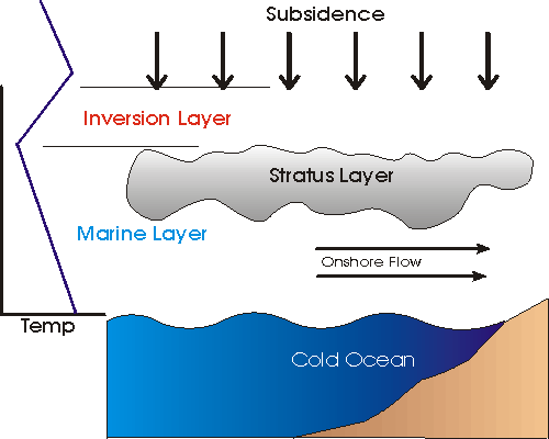
Figure 3: Sinking air associated with the Pacific High meets cool Pacific waters, creating a subsidence inversion and stratus-filled marine layer. Image from http://www.geog.ucsb.edu/~joel/g110_w08/lecture_notes/stability/sub_invert.gif.
SEA SURFACE TEMPERATURES
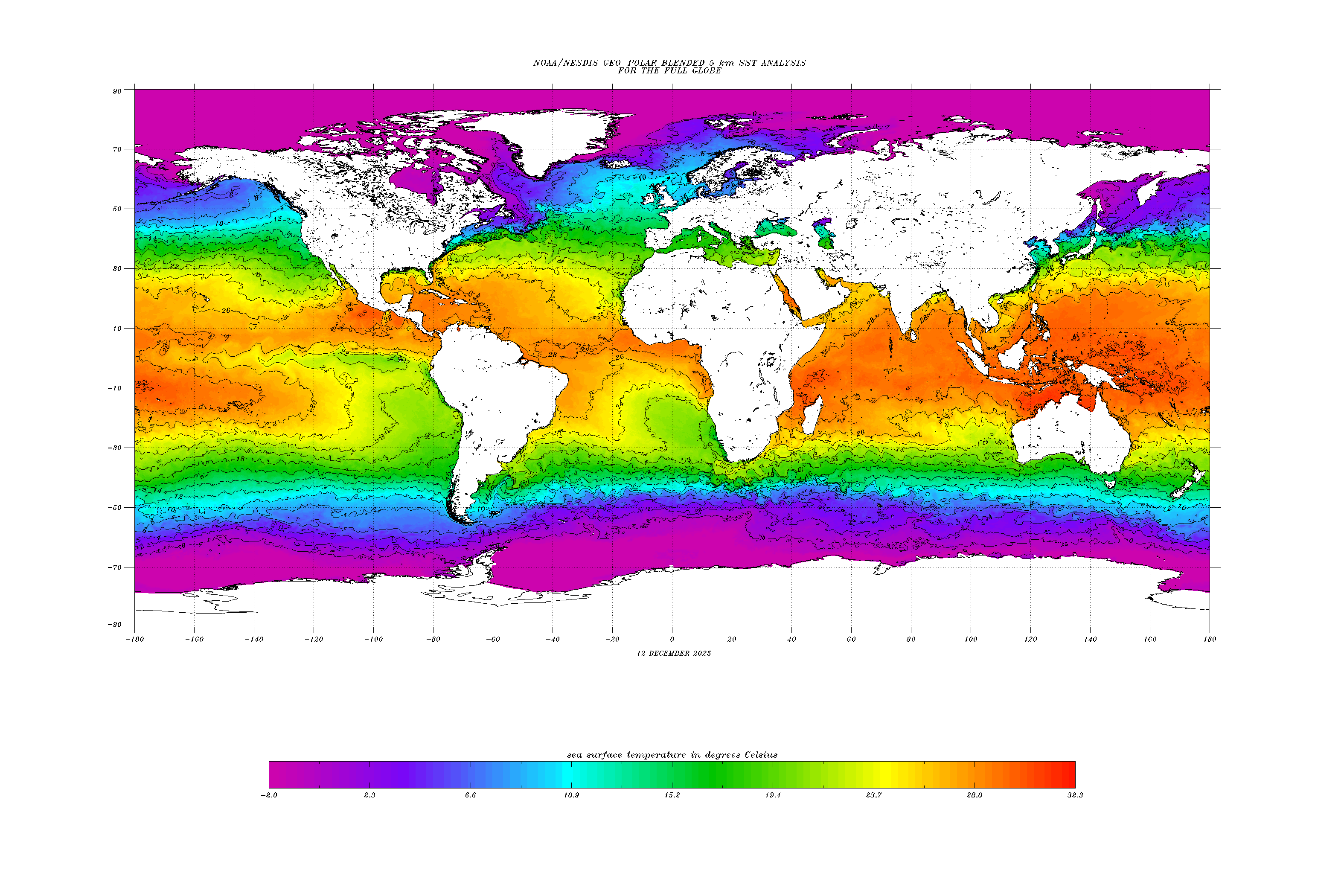
As winds on the eastern side of the Pacific High blow from north to south, upwelling occurs along the west coast of the United States. Due to this upwelling, sea surface temperatures (SSTs) are cooler near the coastline and warm as you head away from the coast. In Figure 4, SSTs for July 1, 2015 are shown and range from 12 degrees C along the coast of California to 26 degrees C as you approach Hawaii.
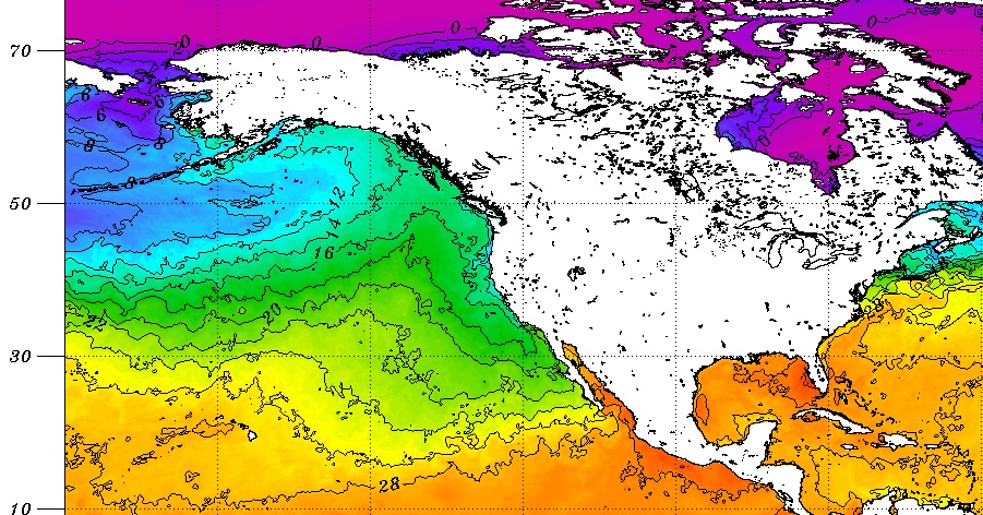
Figure 4. July 1, 2015 sea surface temperatures (Celsius). Image modified from http://www.ospo.noaa.gov/data/sst/contour/global_small.c.gif.
When the Pacific High is located close to its typical position around 30oN and 150oW, this means that the winds on the south side of the high are blowing from NE to SW (the NE trade winds), or from cooler ocean temperatures to warmer ocean temperatures. These changes in SST can affect the type of clouds that form, as shown in the section below.
CLOUDS
While there are many cloud types on Earth, in the subtropical Eastern Pacific, the main cloud types that form are stratus clouds, cumulus clouds, and stratocumulus clouds. Over the water these are known as marine stratus, marine stratocumulus, and trade wind cumulus clouds.
The types of marine clouds that form can be linked to other environmental factors such as SST and lower-tropospheric stability (LTS), which is defined as the potential temperature difference between the surface and 700 hPa. When SST increases, the atmosphere becomes less stable (LTS decreases) and dry air is entrained, which causes the stratus cloud deck to break up and transition to stratocumulus and eventually cumulus clouds as the trade winds continue to blow the air mass toward Hawaii.
The types of marine clouds that form can be linked to other environmental factors such as SST and lower-tropospheric stability (LTS), which is defined as the potential temperature difference between the surface and 700 hPa. When SST increases, the atmosphere becomes less stable (LTS decreases) and dry air is entrained, which causes the stratus cloud deck to break up and transition to stratocumulus and eventually cumulus clouds as the trade winds continue to blow the air mass toward Hawaii.
|
|
|
|
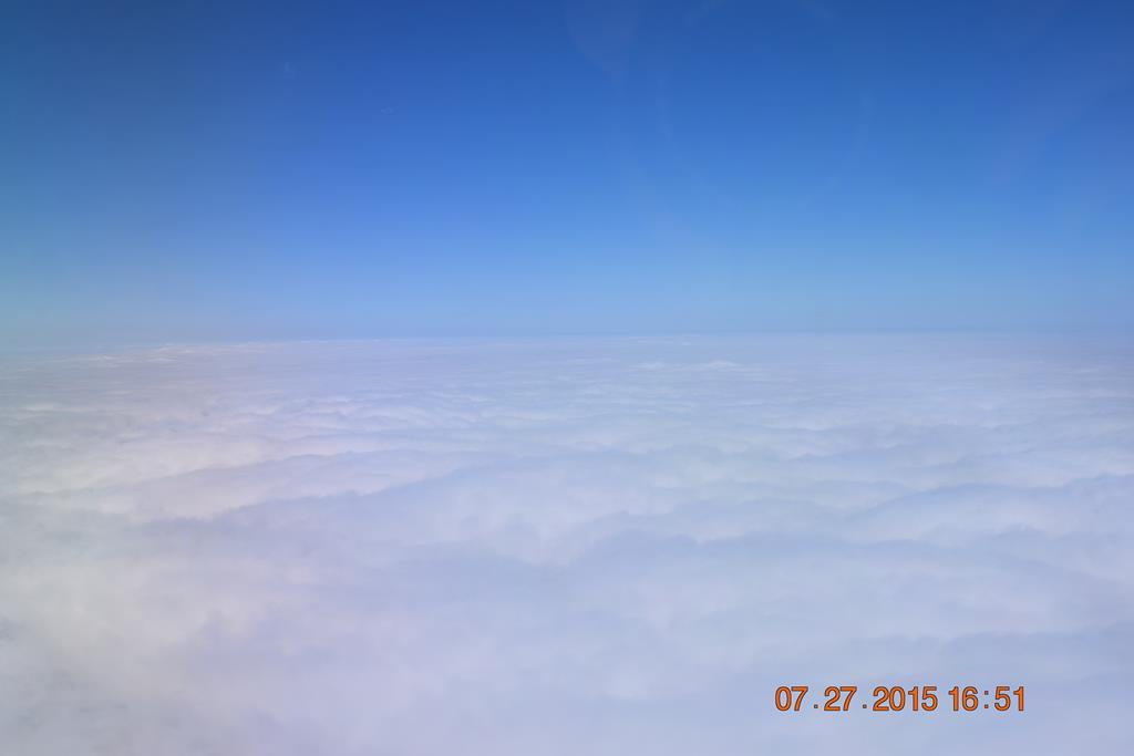
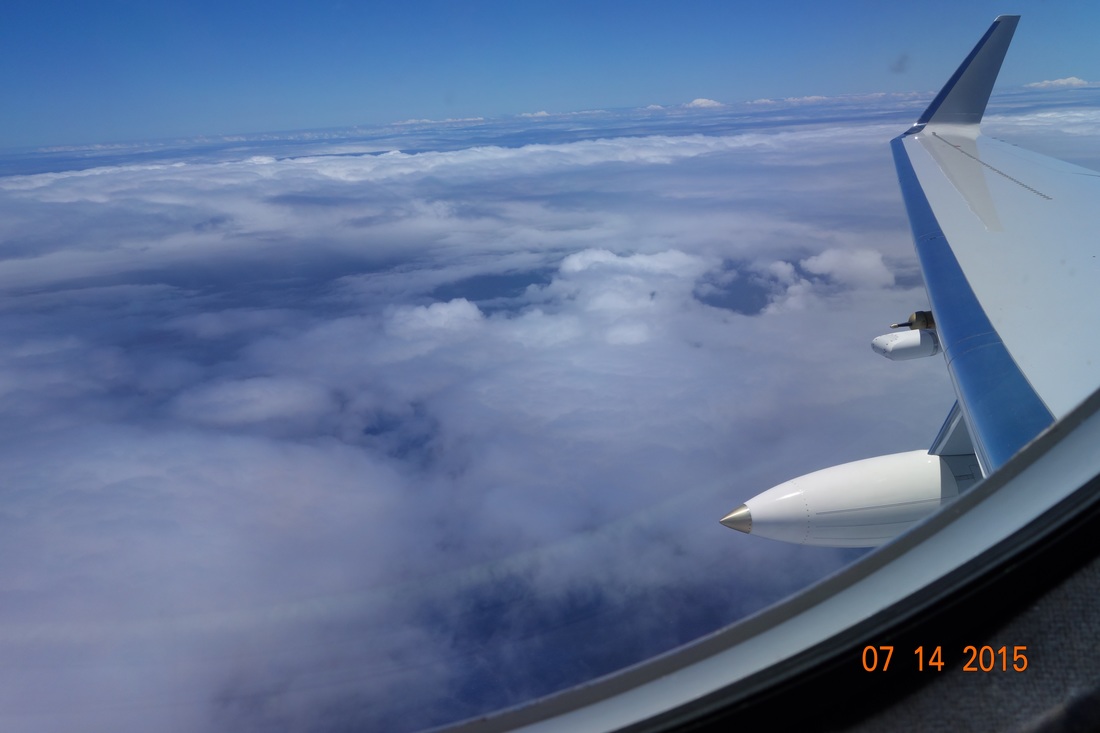
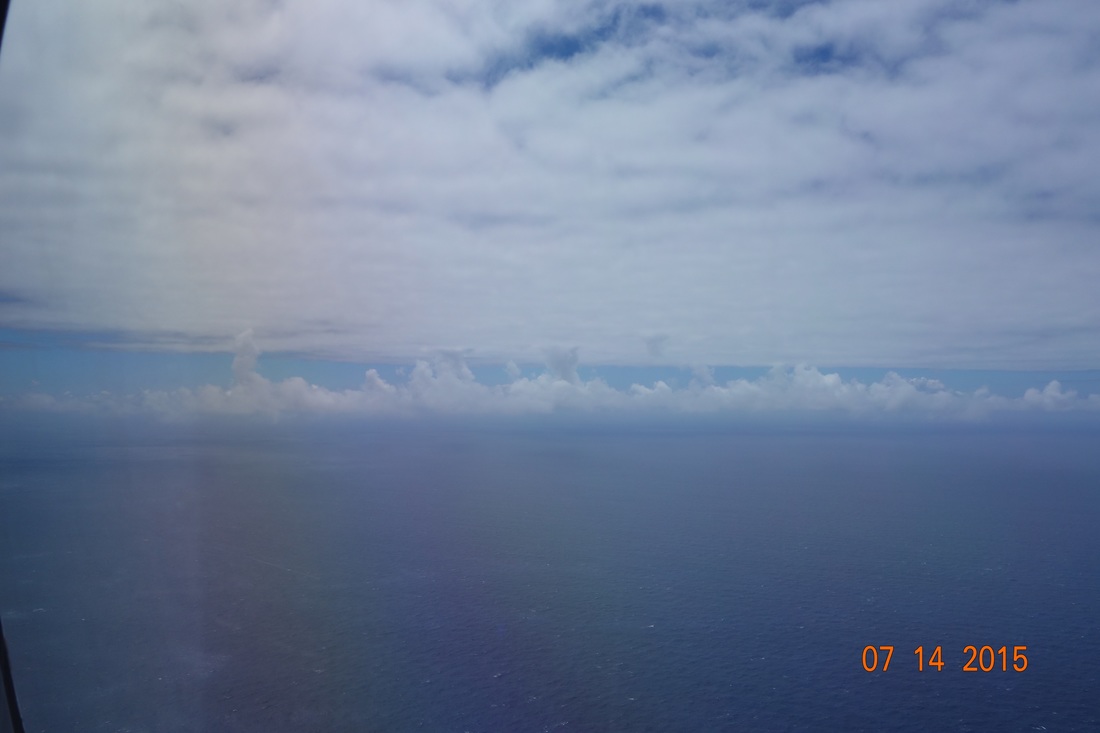
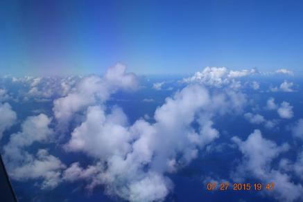
Figure 5. Pictures of clouds from CSET research flights. Clockwise from top left: Stratus during RF10, photo by Rob Wood; Stratocumulus during RF05, photo by Paquita Zuidema; Cumulus during RF10, photo by Rob Wood; Decoupled boundary layer (cumulus below, stratus/stratocumulus above) during RF 05, photo by Paquita Zuidema. For more details on research flights, visit http://catalog.eol.ucar.edu/cset/tools/missions
As seen in Figure 5, marine stratus clouds are the most horizontally extensive, as these are associated with a more stable lower atmosphere (high LTS). Once the atmosphere destabilizes, the clouds transition to stratocumulus and then cumulus clouds, and the clouds will grow vertically instead of horizontally. This leads to colder cloud tops (higher cloud top heights) on a satellite image, and total cloud coverage is lower due to the individual cells that make up cumulus clouds.
As seen in Figure 5, marine stratus clouds are the most horizontally extensive, as these are associated with a more stable lower atmosphere (high LTS). Once the atmosphere destabilizes, the clouds transition to stratocumulus and then cumulus clouds, and the clouds will grow vertically instead of horizontally. This leads to colder cloud tops (higher cloud top heights) on a satellite image, and total cloud coverage is lower due to the individual cells that make up cumulus clouds.
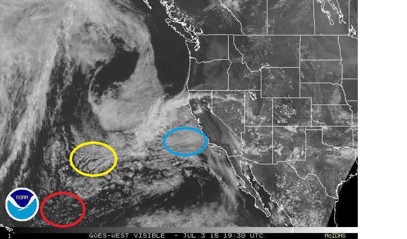
Figure 6: GOES satellite image from 7/3/2015 1930 UTC. The red circle highlights cumulus clouds, the yellow circle highlights stratocumulus clouds, and the blue circle highlights stratus clouds. Image modified from http://www.ssd.noaa.gov/imagery/weus.html.
The stratocumulus clouds found over the cool subtropical waters on the eastern side of the Pacific High evolve into cumulus clouds in the trade winds in the warm tropics on the south side of the high. As the clouds transition, their albedo (reflectivity) and aerial extent decrease, which allows for more incoming solar radiation to reach the ground. Once they have transitioned into cumulii, the convection is deeper, which plays an important role in energy transport in the global hydrological cycle (as seen in Figure 7). During the transition, the MBL evolves from a well-mixed, single layer topped with horizontally extensive clouds under a sharp inversion, into a deeper, vertically-stratified structure containing cumulus clouds with greatly reduced cover capped by a weaker and more diffuse inversion.
Since the clouds in the subtropical northeastern Pacific are constantly evolving, a goal of CSET is not just to study a particular type of cloud, but rather to study the transitions between cloud types.
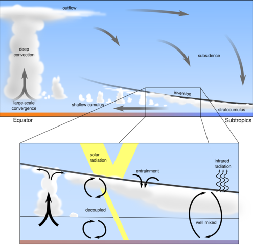
Figure 7: Schematic of the stratus to cumulus transition. On the upper image, stratus and stratocumulus clouds form in the stable MBL to the right side of the image, and transition towards cumulus clouds on the left side of the image. As related to CSET, the right side of this image mimics typical conditions off the coast of California while the left side represents conditions closer to Hawaii. In the transition region (zoomed in region in lower part of image), the lower atmosphere becomes decoupled and two separate regions of the boundary layer exist. Image from http://www.tudelft.nl/uploads/RTEmagicC_Fig_1-3.png.png.
AEROSOL-CLOUD INTERACTIONS
Aerosols are tiny particles in the atmosphere that can come from natural sources such as dust, smoke, or salt, or from manmade pollutants. These particles are usually microscopic in size and range in concentration from < 10 per cubic centimeter in clean marine air to much higher values in polluted air.
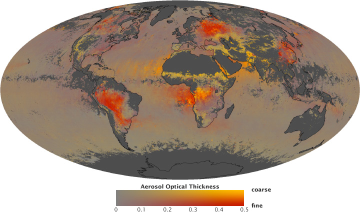
Figure 8: This map shows the global distribution of aerosols and the proportion of those aerosols that are large or small. Intense colors indicate a thick layer of aerosols. Yellow areas are predominantly coarse particles, like dust, and red areas are mainly fine aerosols, like smoke or pollution. Gray indicates areas with no data. Image from http://earthobservatory.nasa.gov/Features/Aerosols/.
When aerosols make it into the lower atmosphere, they can affect cloud formation. The simple story is that clouds form when air becomes saturated (temperature is equal to dewpoint and relative humidity= 100%) as water vapor condenses into liquid cloud droplets. However, one ingredient is missing from that "cloud recipe" and that ingredient is aerosols. These aerosols act as cloud condensation nuclei (CCN) and serve as a surface for water vapor to condense upon to form cloud droplets. Depending on the composition of the aerosols, they can cause clouds to form when relative humidities are <100% (hygroscopic nuclei) or prevent cloud formation until relative humidities are >100% (hydrophobic nuclei).
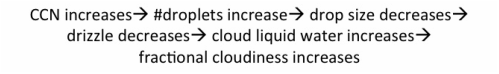
By changing the number of anthropogenic (or manmade) aerosols in the atmosphere, the characteristics of the clouds can be changed. When aerosol concentration increases (CCN count increases) in these low marine clouds, this initiates more cloud droplets condensing than normal. This suggests that while there may be more cloud droplets (droplet concentration increased), the size of each droplet will go down (drop size decreases). Smaller cloud droplets are less likely to precipitate out of clouds (drizzle decreases), which leads to an increased amount of water that remains in the clouds (cloud liquid water increases) and an increase in the fractional cloudiness (Albrecht 1989). This is similar to the process that occurs when ship tracks are seen in satellite images. These ship tracks likely form in areas with low CCN as the aerosols from the ship's smokestack add additional CCN into the atmosphere.
When aerosols make it into the lower atmosphere, they can affect cloud formation. The simple story is that clouds form when air becomes saturated (temperature is equal to dewpoint and relative humidity= 100%) as water vapor condenses into liquid cloud droplets. However, one ingredient is missing from that "cloud recipe" and that ingredient is aerosols. These aerosols act as cloud condensation nuclei (CCN) and serve as a surface for water vapor to condense upon to form cloud droplets. Depending on the composition of the aerosols, they can cause clouds to form when relative humidities are <100% (hygroscopic nuclei) or prevent cloud formation until relative humidities are >100% (hydrophobic nuclei).
By changing the number of anthropogenic (or manmade) aerosols in the atmosphere, the characteristics of the clouds can be changed. When aerosol concentration increases (CCN count increases) in these low marine clouds, this initiates more cloud droplets condensing than normal. This suggests that while there may be more cloud droplets (droplet concentration increased), the size of each droplet will go down (drop size decreases). Smaller cloud droplets are less likely to precipitate out of clouds (drizzle decreases), which leads to an increased amount of water that remains in the clouds (cloud liquid water increases) and an increase in the fractional cloudiness (Albrecht 1989). This is similar to the process that occurs when ship tracks are seen in satellite images. These ship tracks likely form in areas with low CCN as the aerosols from the ship's smokestack add additional CCN into the atmosphere.
The effects of increased aerosol content on marine clouds.
On the other hand, an increase in CCN could also lead to enhanced precipitation under the right conditions. For this to occur, the cloud droplets need to have a range of diameters to initiate cloud droplet growth by the collision-coalescence process. If the droplets combine, they can grow large enough to precipitate. Increased drizzle would help to stabilize the boundary layer due to evaporational cooling as some of the drizzle evaporates beneath cloud base. However, to further complicate matters, if only the region right below the cloud is stabilized or if cloud top entrainment occurs, the cloud and the subcloud layer can become decoupled, limiting the transport of water into the cloud layer and causing the stratus to break up (Albrecht 1989). They are replaced by broken cumulii whose tops are more variable, with a greater spread of cloud top height and fewer clouds reaching the inversion. Another factor to consider is the precipitation cleans CCN out of the air, limiting their ability to affect future clouds in the region.
Since cloud-aerosol effects are not fully understood, they remain an important question in climate change. Different types of clouds have different forcing impacts on the radiation budget: high clouds such as cirrus are thought thought to enhance warming, while low clouds such as stratus are thought to lead to cooling, and deep clouds such as cumulonimbus are thought to have a neutral effect. The types and concentrations of future aerosols are unknown, thus the effects that future clouds may have on the radiative forcing budget are uncertain. Figure 9 showcases the net annual radiative effects of clouds, where negative values lead to cooling and positive values lead to warming. One goal of CSET is to study the effect of aerosols on the clouds transitioning from stratus to cumulus in the Eastern Pacific and how this might lead to a change in their impact on the radiative budget.
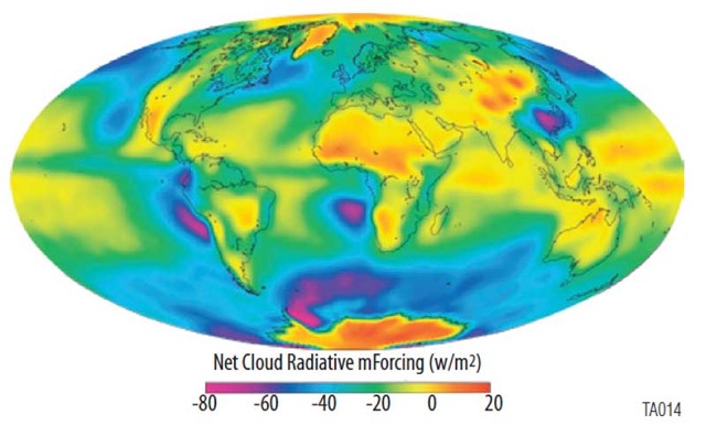
Figure 9. Annual mean net cloud radiative forcing from March 2000-Feb 2001. Note the large area of marine stratus that shows up in blue off the coast of California (and also off the west coasts of several other continents). These shallow clouds have a cooling impact on climate. Image from http://npp.gsfc.nasa.gov.
EL NIÑO- SOUTHERN OSCILLATION
In Spring 2015, a moderate El Niño event began to occur in the Eastern Equatorial Pacific. During an El Niño event, the Walker Circulation weakens or breaks down completely, causing SSTs that are warmer than normal due to a reduction in upwelling off the west coast of South America. Although ENSO is a regional event, it has effects in other areas of the globe (known as a teleconnection). The decrease in trade winds and shift in convection to the center of the tropical Pacific causes the Pacific Jet stream to strengthen and split, as seen in Figure 10. This split causes storms to track along the southern part of the jet stream (the subtropical jet) and bring excess precipitation into Southern California. This pattern also causes ridging over the Western United States along with the northern portion of the jet steam (the polar jet), which can mean above-average temperatures and below-average precipitation for the Pacific Northwest, Alaska, and Western Canada. This pattern causes the largest impacts during the winter months but can also impact weather during the summer.
The El Niño continued to strengthen into Summer 2015, leading to possible shifts in the jet steam and impacts to the Pacific High during CSET. There are also other atmospheric oscillations that have the potential to interact and impact the weather conditions, including the PNA and PDO to consider.
The El Niño continued to strengthen into Summer 2015, leading to possible shifts in the jet steam and impacts to the Pacific High during CSET. There are also other atmospheric oscillations that have the potential to interact and impact the weather conditions, including the PNA and PDO to consider.
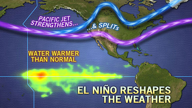
Figure 10. During an El Nino, warm SST anomalies exist in the Eastern Equatorial Pacific leading to changes in the strength and position of the Pacific Jet Stream in the Northern Hemisphere. Image from http://www.accuweather.com/en/weather-news/what-impact-will-the-coming-el/24864631
USEFUL REFERENCES
References students can use to learn more about the scientific background of the CSET experiment:
Bruce A. Albrecht, 1989: Aerosols, Cloud Microphysics, and Fractional Cloudiness. Science, 245 (4923), 1227-1230. http://www.atmos.washington.edu/academics/classes/2008Q2/591A/Articles/albrecht_1227.pdf
Stephen A. Klein, Dennis L. Hartmann, and Joel R. Norris, 1995: On the Relationships among Low-Cloud Structure, Sea Surface Temperature, and Atmospheric Circulation in the Summertime Northeast Pacific. J. Climate, 8, 1140–1155.
doi: http://dx.doi.org/10.1175/1520-0442(1995)008<1140:OTRALC>2.0.CO;2
Joel R. Norris and Stephen A. Klein, 2000: Low Cloud Type over the Ocean from Surface Observations. Part III: Relationship to Vertical Motion and the Regional Surface Synoptic Environment. J. Climate, 13, 245–256. https://www.gfdl.noaa.gov/bibliography/related_files/jrn0001.pdf
Daniel Rosenfeld, Steven Sherwood, Robert Wood, and Leo Donner, 2014: Climate Effects of Aerosol-Cloud Interactions. Science, 343 (6169), 379-380. http://www.sciencemag.org/content/343/6169/379.full.pdf
Lynn M. Russell, Armin Sorooshian, John H. Seinfeld, Bruce A. Albrecht, Athanasios Nenes, Lars Ahlm, Yi-Chun Chen, Matthew Coggon, Jill S. Craven, Richard C. Flagan, Amanda A. Frossard, Haflidi Jonsson, Eunsil Jung, Jack J. Lin, Andrew R. Metcalf, Robin Modini, Johannes Mülmenstädt, Greg Roberts, Taylor Shingler, Siwon Song, Zhen Wang, and Anna Wonaschütz, 2013: Eastern Pacific Emitted Aerosol Cloud Experiment. Bull. Amer. Meteor. Soc., 94, 709–729.
doi: http://dx.doi.org/10.1175/BAMS-D-12-00015.1
Robert Wood, Matthew Wyant, Christopher S. Bretherton, Jasmine Rémillard, Pavlos Kollias, Jennifer Fletcher, Jayson Stemmler, Simone de Szoeke, Sandra Yuter, Matthew Miller, David Mechem, George Tselioudis, J. Christine Chiu, Julian A. L. Mann, Ewan J. O’Connor, Robin J. Hogan, Xiquan Dong, Mark Miller, Virendra Ghate, Anne Jefferson, Qilong Min, Patrick Minnis, Rabindra Palikonda, Bruce Albrecht, Ed Luke, Cecile Hannay, and Yanluan Lin, 2015: Clouds, Aerosols, and Precipitation in the Marine Boundary Layer: An Arm Mobile Facility Deployment. Bull. Amer. Meteor. Soc., 96, 419–440.
doi: http://dx.doi.org/10.1175/BAMS-D-13-00180.1
References on the Stratus-to-Cumulus Transition:
Bretherton, C. S. and R. Pincus, 1995: Cloudiness and Marine Boundary Layer Dynamics in the ASTEX Lagrangian Experiments. Part I: Synoptic setting and vertical structure. J. Atmos. Sci., 52, 2707-2723.
Bretherton, C. S., P. A. Austin and S. T. Siems, 1995: Cloudiness and Marine Boundary Layer Dynamics in the ASTEX Lagrangian Experiments. Part II: Cloudiness, drizzle, surface fluxes and entrainment. J. Atmos. Sci., 52, 2724-2735.
Bretherton, C. S., and M. C. Wyant, 1997: Moisture transport, lower tropospheric stability and decoupling of cloud-topped boundary layers. J. Atmos. Sci. 54, 148–167.
Bretherton, C.S., S.K. Krueger, M.C. Wyant, P. Bechtold, E. Van Meijgaard, B. Stevens, and J. Teixeira, 1999: A GCSS boundary-layer cloud model intercomparison study of the First ASTEX Lagrangian Experiment. Bound.-Lay. Meteorol. 93, 341–380.
C. S. Bretherton and P. N. Blossey, 2014. Low cloud reduction in a greenhouse-warmed climate: Results from Lagrangian LES of a subtropical marine cloudiness transition. J. Adv. Model. Earth Syst., 6, 91-114, doi:10.1002/2013MS000250
Karlsson, J., G. Svensson, S. Cardoso, J. Teixeira, and S. Paradise, 2010: Subtropical cloud-regime transitions: boundary layer depth and cloud-top height evolution in models and observations. J. Appl. Meteor. Climatol. 49, 1845–1858.
Steven K. Krueger, George T. McLean, and Qiang Fu, 1995: Numerical Simulation of the Stratus-to-Cumulus Transition in the Subtropical Marine Boundary Layer. Part I: Boundary-Layer Structure. J. Atmos. Sci., 52, 2839–2850.
doi: http://dx.doi.org/10.1175/1520-0469(1995)052<2839:NSOTST>2.0.CO;2
S. R. de Roode, I. Sandu, J. J. van der Dussen, A. S. Ackerman, P. Blossey, D. Jarecka, A. Lock, A. P. Siebesma, and B. Stevens. Shallow cumulus control on the stratocumulus lifetime: LES results of EUCLIPSE/GASS Lagrangian stratocumulus transitions. Submitted 07/2015
Sandu, I, B. Stevens, and R. Pincus, 2010: On the transitions in marine boundary layer cloudiness., Atmos. Chem. Phys., 10, 2377–2391,
Sandu, I., and B. Stevens, 2011: On the factors modulating the stratocumulus to cumulus transitions. J. Atmos. Sci., 1865-, doi: 10.1175/2011JAS3614.1.
Teixeira, J., and co-authors, 2011: Tropical and sub-tropical cloud transitions in weather and climate prediction models: The GCSS/WGNE Pacific cross-section intercomparison (GPCI). J. Climate, 24, 5223-5256.
van der Dussen, J. J., and coauthors, 2013: The GASS/EUCLIPSE Model Intercomparison of the Stratocumulus Transition as Observed During ASTEX: LES results. J. Adv. Model. Earth Syst., 5, p. 483-499. doi:10.1002/jame.20033
Wyant, M.C., C.S. Bretherton, H.A. Rand, and D.E. Stevens, 1997: Numerical simulations and a conceptual model of the stratocumulus to trade cumulus transition. J. Atmos. Sci. 54, 168–192.
Additional references for advanced atmospheric science students:
Virendra P. Ghate, Mark A. Miller,and Lynne DiPretore, 2001: Vertical velocity structure of marine boundary layer trade wind cumulus clouds. J. Geophys. Res., 116, D16206.
doi: http://dx.doi.org/10.1029/2010JD015344.
Robert Wood and Christopher S. Bretherton, 2006: On the Relationship between Stratiform Low Cloud Cover and Lower-Tropospheric Stability. J. Climate, 19, 6425–6432. http://www.atmos.washington.edu/~robwood/papers/eis/eis_final.pdf
